Wake Cemetery Survey by Township c.1978
The Wake County Cemetery Project preserves one of the county's most valuable genealogical resources - a comprehensive 1978 cemetery survey documenting thousands of burials across Wake County. In this collection you will find digitized survey forms, maps, grave inscriptions and more from all over Wake County. There are hundreds of clues to fill in your Wake County story.
Survey History
The Wake Cemetery Survey by Township, c. 1978 is a gold mine for any researcher with Wake County roots. It sprang out of a short-lived government effort to update the previous cemetery census conducted statewide by the WPA in the late 1930s. The state discontinued their effort when they decided that they could not force counties to comply. It fell to dedicated survey volunteers across the state to redouble their efforts as grassroots citizen led projects in the various counties.
In 2021-2026, WCGS digitized these records with an eye to providing an experience that is as close to viewing the originals as possible. In addition to the vital statistics that are a part of any Cemetery Survey, the jewels of this record set are the copious notes and family connections scribbled in the margins, on post-it notes, and any spare bit of paper. If you have Wake ancestors to research, you will really want to check this record set. It will surely enrich your research.
Research Tips
The survey is organized by Townships (see list below). Here are some ideas and suggestions for working with the data.
If you have a surname but not the township, try this Surname Finder if your people were buried in a smaller family cemetery. This is a global listing but includes only Family cemeteries, not Church or Community.
Wake Cemetery Survey Image Collection: Tips for Successful Searches - This is an overview of using the survey. (Reprinted from WGW Newsletter, Summer 2024.)
Townships
Bartons Creek – including cemeteries displaced by the Falls Lake Reservoir Project, and a portion of Raleigh and a portion of Durham county that was formerly part of Wake County
Buckhorn – including cemeteries displaced by the Shearon Harris Nuclear Plant and Reservoir and small portions of Apex and Holly Springs
Cary – including the town of Cary and portions of Apex and Raleigh
Cedar Fork – including the town of Morrisville and cemeteries displaced by improvements to Raleigh-Durham Airport, and portions of Cary and Raleigh. A portion of Cedar Fork was also carved off to Durham County when it was created.
Holly Springs – including the town of Holly Springs and portions of Apex and Fuqua-Varina
House Creek - including portions of Raleigh
Leesville – including portions of Raleigh
Little River – including the town of Zebulon
Marks Creek – including the town of Wendell
Meredith – including portions of Raleigh
Middle Creek – including the town of Fuquay-Varina and portions of Holly Springs
Neuse - including portions of Raleigh
New Light – including cemeteries displaced by the Falls Lake Reservoir Project
Panther Branch – including small portions of Garner
Raleigh – including the city of Raleigh and downtown
Saint Mary’s – including the town of Garner and portions of Raleigh
Saint Matthews – including the town of Knightdale and portions of Raleigh
Swift Creek – including portions of Cary, Garner and the city of Raleigh
Wake Forest – including the towns of Wake Forest and Rolesville and a portion of Raleigh
White Oak – including the town of Apex and portions of Cary
Unsure which part of Wake County to search? Use this Township Map to identify townships in the area of interest.
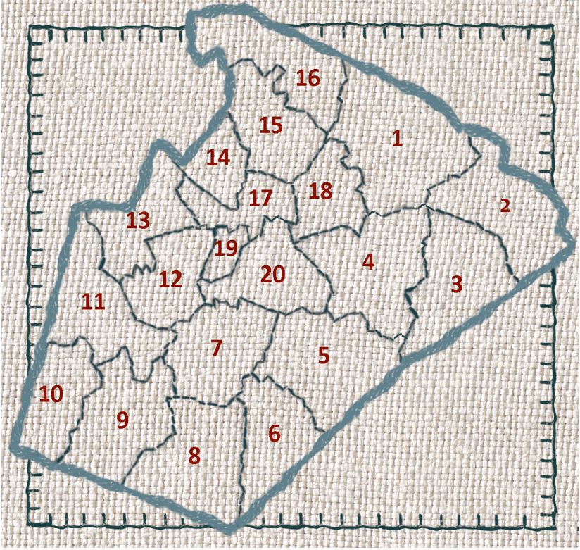
Art: Wake County Embroidery Graphic by Jay Burnett. Stitching Photoshop and Gimp Brushes by www.obsidiandawn.com. Homespun Fabric Background by iSidhe via iStock by Getty Images.
Project History and Details
See the References page for how this data came to light, and the people and processes involved.